Doug Stone Maps
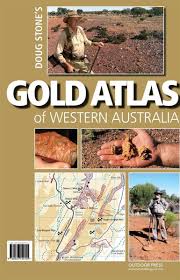
Gold Atlas Western Australia WA
Gold Atlas Western Australia WA
Couldn't load pickup availability
Uncover Western Australia's Rich Gold History
Explore over 30 years of Doug Stone’s prospecting and mapping expertise in one comprehensive volume built for serious prospectors and metal detector operators.
🗺️ Detailed Prospecting Maps: Includes 85 pages of meticulously detailed maps, featuring new release maps and colour photographs.
✅ Extensive Coverage: Covers both historical and modern alluvial and reef mining areas, including tracks, dams, creeks, landmarks, and known nugget locations, with some GPS coordinates included.
🌍 Key Goldfield Districts: Features major prospecting regions including Halls Creek, Marble Bar, Meekatharra, Leonora, Laverton, Menzies, Kalgoorlie and more.
Doug Stone’s decades of fieldwork and prospecting knowledge have created an essential reference for anyone exploring the rich goldfields of Western Australia.
Specifications
- Hard cover, spiral bound
- Measures: 27cm × 40cm × 1cm thick
- Approximate weight: 1kg
Locations Included
- Halls Creek District – Old Halls Creek Goldfields, Brockman Goldfield, Mary River Battery, Thompson Goldfield, Mount Dockrell Goldfield
- Marble Bar – Karratha District – Four Mile Diggings, Salgash Diggings, Owens Gully, Tambourah, Nullagine, Mosquito Creek, Whim Creek, Bernies Patch
- Meekatharra – Sandstone District – Lake Annean, Quinns, Sebastapol, Redcastle Well, Gidgee, Black Range, Nunngarra, Six Mile & Raffertys Patch
- Lake Darlot District – Mt Keith, Bill & Simms, Barwidgee, Melrose Station, Freemans Find, Billy Bore, Hootuni, Duketon, McKenzie Well
- Laverton – Lake Carey District – Hawks Nest, Biddy’s Patch, Euro Mine, Wilga, Pyke Hollow, Eucalyptus
- Leonora District – Puzzle Mines, Mertondale, The Triangle, Snowdon Bore, Mount Flora, Cement Tank Diggings, Agnew & Jasper Hill
- Menzies District – Kookynie, Yerilla, Menzies South, Menzies East
- Kalgoorlie – Boulder District – Edjudina, Mulgabbie, Carnage, Carbine, Lindsay Well, Kalpini, Garibaldi, Jubilee, Grey Dam, Kurnalpi
Share